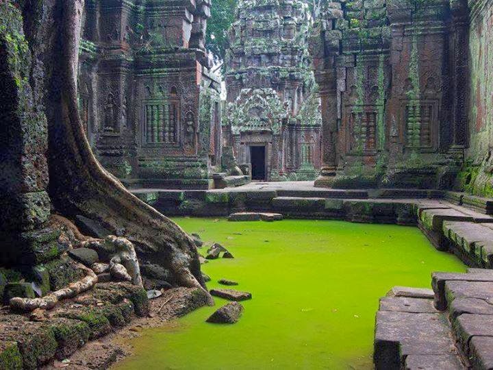
Ta Prohm is the modern name of the temple at Angkor, Siem Reap Province, Cambodia, built in the Bayon style largely in the late 12th and early 13th centuries and originally called Rajavihara . Located approximately one kilometre east of Angkor Thom and on the southern edge of the East Baray, it was founded by the Khmer King Jayavarman VII as a Mahayana Buddhist monastery and university. Unlike most Angkorian temples, Ta Prohm has been left in much the same condition in which it was found: the photogenic and atmospheric combination of trees growing out of the ruins and the jungle surroundings have made it one of Angkor's most popular temples with visitors.
UNESCO inscribed Ta Prohm on the World Heritage List in 1992. Today, it is one of the most visited complexes in Cambodia’s Angkor region. The conservation and restoration of Ta Prohm is a partnership project of the Archaeological Survey of India and the APSARA (Authority for the Protection and Management of Angkor and the Region of Siem Reap).
Foundation and expansion
In 1186 A.D., Jayavarman VII embarked on a massive program of construction and public works. Rajavihara ("monastery of the king"), today known as Ta Prohm ("ancestor Brahma"), was one of the first temples founded pursuant to that program. The stele commemorating the foundation gives a date of 1186 A.D.
Jayavarman VII constructed Rajavihara in honor of his family. The temple's main image, representing Prajnaparamita, the personification of wisdom, was modelled on the king's mother. The northern and southern satellite temples in the third enclosure were dedicated to the king's guru and his elder brother respectively. As such, Ta Prohm formed a complementary pair with the temple monastery of Preah Khan, dedicated in 1191 A.D., the main image of which represented the Bodhisattva of compassion Lokesvara and was modelled on the king's father.
The temple's stele records that the site was home to more than 12,500 people (including 18 high priests and 615 dancers), with an additional 800,000 souls in the surrounding villages working to provide services and supplies. The stele also notes that the temple amassed considerable riches, including gold, pearls and silks.
Expansions and additions to Ta Prohm continued as late as the rule of Srindravarman at the end of the 15th century.
The design of Ta Prohm is that of a typical "flat" Khmer temple (as opposed to a temple-pyramid or temple-mountain, the inner levels of which are higher than the outer). Five rectangular enclosing walls surround a central sanctuary. Like most Khmer temples, Ta Prohm is oriented to the east, so the temple proper is set back to the west along an elongated east-west axis. The outer wall of 1000 by 650 metres encloses an area of 650,000 square metres that at one time would have been the site of a substantial town, but that is now largely forested. There are entrance gopuras at each of the cardinal points, although access today is now only possible from the east and west. In the 13th century, face towers similar to those found at the Bayon were added to the gopuras. Some of the face towers have collapsed. At one time, moats could be found inside and outside the fourth enclosure.
The three inner enclosures of the temple proper are galleried, while the corner towers of the first enclosure form a quincunx with the tower of the central sanctuary. This basic plan is complicated for the visitor by the circuitous access necessitated by the temple's partially collapsed state, as well as by the large number of other buildings dotting the site, some of which represent later additions. The most substantial of these other buildings are the libraries in the southeast corners of the first and third enclosures; the satellite temples on the north and south sides of the third enclosure; the Hall of Dancers between the third and fourth eastern gopuras; and a House of Fire east of the fourth eastern gopura.
Friday, 29 November 2013
The Big Hole in the Northern Cape, South Africa
The Big Hole, Open Mine or Kimberley Mine (Afrikaans: Groot Gat) is an open-pit and underground mine in Kimberley, South Africa, and claimed to be the largest hole excavated by hand.The first diamonds here were found on Colesberg Kopje by members of the "Red Cap Party" from Colesberg on the farm Vooruitzigt belonging to the De Beers brothers. The ensuing scramble for claims led to the place being called New Rush, later renamed Kimberley. From mid-July 1871 to 1914 up to 50,000 miners dug the hole with picks and shovels, yielding 2,720 kilograms (6,000 lb) of diamonds. The Big Hole has a surface of 17 hectares (42 acres) and is 463 metres (1,519 ft) wide. It was excavated to a depth of 240 metres (790 ft), but then partially infilled with debris reducing its depth to about 215 metres (705 ft). Since then it has accumulated about 40 metres (130 ft) of water, leaving 175 metres (574 ft) of the hole visible. Once above-ground operations became too dangerous and unproductive, the kimberlite pipe of the Kimberley Mine was also mined underground by Cecil Rhodes' De Beers company to a depth of 1,097 metres (3,599 ft).
Wailua Falls, island of Kauai, Hawaii
Wailua Falls is an 113-foot waterfall located in Kauai, Hawaii that feeds into the Wailua River. There are paths to the bottom of the falls, but it can be muddy, slippery and dangerous. The "trail" further from the parking lot is less steep than the closer one. Some hikers have strung ropes along the paths, but officials come by every so often and cut them. In ancient times, Hawaiian men would jump from the top of the falls to prove their manhood. And people still leap off, though it is dangerous and illegal. The pool is great swimming, but do not go near the waterfall as the currents are very dangerousThursday, 28 November 2013
Tacca Chantrieri
The Black bat flower, Tacca chantrieri, is a species of flowering plant in the yam family Dioscoreaceae. Tacca chantrieri is an unusual species in that it has black flowers. These flowers are somewhat bat-shaped, are up to 12 inches across, and have long 'whiskers' that can grow up to 28 inches. There are different colour types, including white and brown, both retaining the whiskers of the black variety.Tacca chantrierei grow wild in the tropical forest in Yunnan Province, China, where they can get as tall as 36 inches (~0.91 metres). They grow best in well-drained soil and high humidity but are hardy down to -3C.
Velella
Velella is a cosmopolitan genus of free-floating hydrozoans that live on the surface of the open ocean. There is only one known species, Velella velella, in the genus. Velella velella is commonly known by the names sea raft, by-the-wind sailor, purple sail, little sail, or simply Velella.
These small cnidarians are part of a specialised ocean surface community which includes the better-known cnidarian siphonophore, the Portuguese Man o' War. Specialized predatory gastropod mollusks prey on these cnidarians. Such predators include nudibranchs (sea slugs) in the genus Glaucus and purple snails in the genus Janthina.
Each apparent individual Velella velella is in fact a hydroid colony, and most are less than about 7 cm long. They are usually deep blue in colour, but their most obvious feature is a small stiff sail that catches the wind and propels them over the surface of the sea. Under certain wind conditions, they may be stranded by the thousand on beaches.
Like other Cnidaria, Velella velella are carnivorous. They catch their prey, generally plankton, by means of tentacles that hang down in the water and bear cnidocysts (also called nematocysts). Though the toxins in their nematocysts are effective against their prey, V. velella is harmless to humans, either because its nematocysts are unable to pierce the skin, or perhaps because humans do not react to the toxins encapsulated in their nematocysts. Nevertheless, it is wise to avoid touching one's face or eyes after handling
Wednesday, 27 November 2013
Mount Assiniboine
Mount Assiniboine, also known as Assiniboine Mountain, is a mountain located on the Great Divide, on the British Columbia/Alberta border in Canada.At 3,618 m (11,870 ft), it is the highest peak in the Southern Continental Ranges of the Canadian Rockies. Due to Assiniboine's pyramidal shape, it has been unofficially named the "Matterhorn" of North America. Mt. Assiniboine rises nearly 1,525 m (5,003 ft) above Lake Magog.
Mt. Assiniboine was named by George M. Dawson in 1885. When Dawson saw Mt. Assiniboine from Copper Mountain, he saw a plume of clouds trailing away from the top. This reminded him of the plumes of smoke emanating from the teepees of Assiniboine Indians.
Mt. Assiniboine lies on the border between Mount Assiniboine Provincial Park, in British Columbia, and Banff National Park, in Alberta. The park does not have any roads and thus can only be reached by a six hour hike 27 km (17 mi), three hour bike ride (now disallowed to reduce human / grizzly encounters) or helicopter. The usual approach is via Bryant Creek. From Canmore, Alberta follow the Smith-Dorien road to the Mount Shark parking lot. The trail is well signed. A helipad is also here.
Seychelles
Seychelles , officially the Republic of Seychelles (French: République des Seychelles; Creole: Repiblik Sesel), is a 115-island country spanning an archipelago in the Indian Ocean, some 1,500 kilometres (932 mi) east of mainland Africa, northeast of the island of Madagascar.
Other nearby island countries and territories include Zanzibar to the west, Mauritius, Rodrigues, Agaléga and Réunion to the south, and Comoros and Mayotte to the southwest. Seychelles, with an estimated population of 86,525, has the smallest population of any African state. It has the highest Human Development Index in Africa and the highest income inequality in the world, as measured by the Gini index. Seychelles is a member of the African Union.
Scholars assume that Austronesian seafarers and later Maldivian and Arab traders were the first to visit the uninhabited Seychelles. Remains of Maldivian mariner presence from the 12th century were found in Silhouette Island. The earliest recorded sighting by Europeans took place in 1502 by the Portuguese Admiral Vasco da Gama, who passed through the Amirantes and named them after himself (islands of the Admiral).
A transit point for trade between Africa and Asia, the islands were occasionally used by pirates until the French began to take control starting in 1756 when a Stone of Possession was laid by Captain Nicholas Morphey. The islands were named after Jean Moreau de Séchelles, Louis XV's Minister of Finance.
The British contested control over the islands between 1794 and 1810. Jean Baptiste Quéau de Quincy, French administrator of Seychelles during the years of war with the United Kingdom, declined to resist when armed enemy warships arrived. Instead, he successfully negotiated the status of capitulation to Britain which gave the settlers a privileged position of neutrality.
Britain eventually assumed full control upon the surrender of Mauritius in 1810, formalised in 1814 at the Treaty of Paris. Seychelles became a crown colony separate from Mauritius in 1903. Elections were held in 1966 and 1970. Independence was granted in 1976 as a republic within the Commonwealth. In 1977, a coup d'état ousted the first president of the republic, James Mancham, who was replaced by France Albert René. The 1979 constitution declared a socialist one-party state, which lasted until 1991. The first draft of a new constitution failed to receive the requisite 60% of voters in 1992, but an amended version was approved in 1993.
In January 2013, the country declared a state of emergency; the tropical cyclone Felleng caused torrential rain, and flooding and landslides destroyed hundreds of houses.
Subscribe to:
Posts (Atom)


