Saturday, 30 November 2013

Golden Pheasant

             The Golden Pheasant or "Chinese Pheasant", (Chrysolophus pictus) is a gamebird of the order Galliformes (gallinaceous birds) and the family Phasianidae. It is native to forests in mountainous areas of western China, but feral populations have been established in the United Kingdom and elsewhere. In England they may be found in East Anglia in the dense forest landscape of the Breckland.
The adult male is 90–105 cm in length, its tail accounting for two-thirds of the total length. It is unmistakable with its golden crest and rump and bright red body. The deep orange "cape" can be spread in display, appearing as an alternating black and orange fan that covers all of the face except its bright yellow eye with a pinpoint black pupil.

             Males have a golden-yellow crest with a hint of red at the tip. The face, throat, chin, and the sides of neck are rusty tan. The wattles and orbital skin are both yellow in colour, and the ruff or cape is light orange. The upper back is green and the rest of the back and rump is golden-yellow. The tertiaries are blue whereas the scapulars are dark red. Other characteristics of the male plumage are the central tail feathers, black spotted with cinnamon, as well as the tip of the tail being a cinnamon buff. The upper tail coverts are the same colour as the central tail feathers. The male also has a scarlet breast, and scarlet and light chestnut flanks and underparts. Lower legs and feet are a dull yellow.
             The female (hen) is much less showy, with a duller mottled brown plumage similar to that of the female Common Pheasant. She is darker and more slender than the hen of that species, with a proportionately longer tail (half her 60–80 cm length). The female's breast and sides are barred buff and blackish brown, and the abdomen is plain buff. She has a buff face and throat. Some abnormal females may later in their lifetime get some male plumage. Lower legs and feet are a dull yellow.
           

Both males and females have yellow legs and yellow bills.
             Despite the male's showy appearance, these hardy birds are very difficult to see in their natural habitat, which is dense, dark young conifer forests with sparse undergrowth. Consequently, little is known about their behaviour in the wild.
             They feed on the ground on grain, leaves and invertebrates, but they roost in trees at night. While they can fly, they prefer to run. If startled, they can suddenly burst upwards at great speed and with a distinctive wing sound.
             Although they can fly in short bursts, they are quite clumsy in flight and spend most of their time on the ground. Golden Pheasants lay 8-12 eggs at a time and will then incubate these for around 22–23 days. They tend to eat berries, grubs, seeds and other types of vegetation.
             The male has a metallic call in the breeding season.
             The Golden Pheasant is commonly found in zoos and aviaries, but often as impure specimens that have the similar Lady Amherst's Pheasant in their lineage.
             There are also different mutations of the Golden Pheasant known from birds in captivity, including the Dark-throated, Yellow, Cinnamon, Salmon, Peach, Splash, Mahogony and Silver. In aviculture, the wild type is referred to as "Red Golden" to differentiate it from these mutations.

Crater Lake National Park, Oregon, USA

               Crater Lake National Park is a United States National Park located in southern Oregon. Established in 1902, Crater Lake National Park is the fifth oldest national park in the United States and the only one in the state of Oregon.
The park encompasses the caldera of Crater Lake, a remnant of a destroyed volcano, Mount Mazama, and the surrounding hills and forests.
               The lake is 1,943 feet (592 m) deep at its deepest point, which makes it the deepest lake in the United States, the second deepest in North America and the ninth deepest in the world. Crater Lake is often referred to as the seventh deepest lake in the world, but this former listing excludes the approximately 3,000-foot (910 m) depth of subglacial Lake Vostok in Antarctica, which resides under nearly 13,000 feet (4,000 m) of ice, and the recent report of a 2,740-foot (840 m) maximum depth for Lake O'Higgins/San Martin, located on the border of Chile and Argentina. However, when comparing its average depth of 1,148 feet (350 m) to the average depth of other deep lakes, Crater Lake becomes the deepest in the Western Hemisphere and the third deepest in the world. The impressive average depth of this volcanic lake is due to the nearly symmetrical 4,000-foot (1,200 m) deep caldera formed 7,700 years ago during the violent climactic eruptions and subsequent collapse of Mount Mazama and the relatively moist climate that is typical of the crest of the Cascade Range.
               The caldera rim ranges in elevation from 7,000 to 8,000 feet (2,100 to 2,400 m). The United States Geological Survey benchmarked elevation of the lake surface itself is 6,178 feet (1,883 m). This National Park encompasses 183,225 acres (286.29 sq mi; 741.49 km2).Crater Lake has no streams flowing into or out of it. All water that enters the lake is eventually lost from evaporation or subsurface seepage. The lake's water commonly has a striking blue hue, and the lake is re-filled entirely from direct precipitation in the form of snow and rain.

Taj Mahal, India

           
             The Taj Mahal  is a white marble mausoleum located in Agra, Uttar Pradesh, India. It was built by Mughal emperor Shah Jahan in memory of his third wife, Mumtaz Mahal. The Taj Mahal is widely recognized as "the jewel of Muslim art in India and one of the universally admired masterpieces of the world's heritage".
Taj Mahal is regarded by many as the finest example of Mughal architecture, a style that combines elements from Islamic, Persian, Ottoman Turkish and Indian architectural styles.
             In 1983, the Taj Mahal became a UNESCO World Heritage Site. While the white domed marble mausoleum is the most familiar component of the Taj Mahal, it is actually an integrated complex of structures. The construction began around 1632 and was completed around 1653, employing thousands of artisans and craftsmen. The construction of the Taj Mahal was entrusted to a board of architects under imperial supervision, including Abd ul-Karim Ma'mur Khan, Makramat Khan, and Ustad Ahmad Lahauri. Lahauri is generally considered to be the principal designer.

Turquoise, Plitvice Lake, Croatia

             Plitvice Lakes National Park (Croatian: Nacionalni park Plitvička jezera, colloquial Plitvice is the oldest national park in Southeast Europe and the largest national park in Croatia.
The national park was founded in 1949 and is situated in the mountainous karst area of central Croatia, at the border to Bosnia and Herzegovina. The important north-south road connection, which passes through the national park area, connects the Croatian inland with the Adriatic coastal region.
             The protected area extends over 296.85 square kilometres (73,350 acres). About 90% of this area are part of Lika-Senj County, while the remaining 10% are part of Karlovac County.

Athabasca Falls At Dusk, Jasper, Alberta, Canada

              Athabasca Falls is a waterfall in Jasper National Park on the upper Athabasca River, approximately 30 kilometres south of the townsite of Jasper, Alberta, Canada, and just west of the Icefields Parkway. A powerful, picturesque waterfall, Athabasca Falls is not known so much for the height of the falls (23 metres), as it is known for its force due to the large quantity of water falling into the gorge. Even on a cold morning in the fall, when river levels tend to be at their lowest, copious amounts of water flow over the falls. The river 'falls' over a layer of hard quartzite and through the softer limestone below carving the short gorge and a number of potholes. The falls can be safely viewed and photographed from various viewing platforms and walking trails around the falls. Access is from the nearby parking lot, which leads off Highway 93A just northeast of the falls. Highway 93A takes off from the nearby Icefields Parkway, and crosses the falls on the way north to the town of Jasper. White water rafting often starts below the falls to travel downstream on the Athabasca River to Jasper.
             
It is a Class 5 waterfall, with a drop of 80 ft (24 m) and a width of 60 ft (18 m)

Antelope Canyon, Arizona

           Antelope Canyon is the most-visited and most-photographed slot canyon in the American Southwest.It is located on Navajo land near Page, Arizona. Antelope Canyon includes two separate, photogenic slot canyon sections, referred to individually as Upper Antelope Canyon or The Crack; and Lower Antelope Canyon or The Corkscrew.
           The Navajo name for Upper Antelope Canyon is Tsé bighánílíní, which means "the place where water runs through rocks." Lower Antelope Canyon is Hazdistazí (advertised as "Hasdestwazi" by the Navajo Parks and Recreation Department), or "spiral rock arches." Both are located within the LeChee Chapter of the Navajo Nation.

The ornate horned frog

                The Argentine Horned Frog (Ceratophrys ornata), also known as the Argentine wide-mouthed Frog or Pacman frog, is the most common species of Horned Frog, from the rain forests of Argentina, Uruguay and Brazil. A voracious eater, it will attempt to swallow anything that moves close to its wide mouth, such as insects, and rodents, lizards and other frogs, even if this predator would suffocate in the process.

               
The females can grow to be 16.5 centimeters (6.5 inches) snout to vent (SV) and the males 11.5 centimeters (4.5 in) SV. The average lifespan is 6 to 7 years, however they can live up to 10 years or more in captivity. The Horned frogs' most prominent feature is its mouth, which accounts for roughly half of the animal's overall size. Coloration is typically bright green with red markings, though dark green, parti-color black and albino versions also exist. Sexing this species is very difficult before sexual maturity is reached. Dimorphism traits between the two sexes are size difference and males possessing dark pigmented throats and nuptial pads on the forelimbs

Friday, 29 November 2013

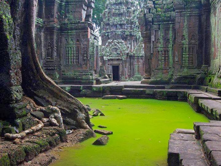
Ta Prohm Temple, Cambodia

             Ta Prohm is the modern name of the temple at Angkor, Siem Reap Province, Cambodia, built in the Bayon style largely in the late 12th and early 13th centuries and originally called Rajavihara . Located approximately one kilometre east of Angkor Thom and on the southern edge of the East Baray, it was founded by the Khmer King Jayavarman VII as a Mahayana Buddhist monastery and university. Unlike most Angkorian temples, Ta Prohm has been left in much the same condition in which it was found: the photogenic and atmospheric combination of trees growing out of the ruins and the jungle surroundings have made it one of Angkor's most popular temples with visitors.
              UNESCO inscribed Ta Prohm on the World Heritage List in 1992. Today, it is one of the most visited complexes in Cambodia’s Angkor region. The conservation and restoration of Ta Prohm is a partnership project of the Archaeological Survey of India and the APSARA (Authority for the Protection and Management of Angkor and the Region of Siem Reap).


Foundation and expansion


             In 1186 A.D., Jayavarman VII embarked on a massive program of construction and public works. Rajavihara ("monastery of the king"), today known as Ta Prohm ("ancestor Brahma"), was one of the first temples founded pursuant to that program. The stele commemorating the foundation gives a date of 1186 A.D.
             Jayavarman VII constructed Rajavihara in honor of his family. The temple's main image, representing Prajnaparamita, the personification of wisdom, was modelled on the king's mother. The northern and southern satellite temples in the third enclosure were dedicated to the king's guru and his elder brother respectively. As such, Ta Prohm formed a complementary pair with the temple monastery of Preah Khan, dedicated in 1191 A.D., the main image of which represented the Bodhisattva of compassion Lokesvara and was modelled on the king's father.
             The temple's stele records that the site was home to more than 12,500 people (including 18 high priests and 615 dancers), with an additional 800,000 souls in the surrounding villages working to provide services and supplies. The stele also notes that the temple amassed considerable riches, including gold, pearls and silks.
Expansions and additions to Ta Prohm continued as late as the rule of Srindravarman at the end of the 15th century.

             The design of Ta Prohm is that of a typical "flat" Khmer temple (as opposed to a temple-pyramid or temple-mountain, the inner levels of which are higher than the outer). Five rectangular enclosing walls surround a central sanctuary. Like most Khmer temples, Ta Prohm is oriented to the east, so the temple proper is set back to the west along an elongated east-west axis. The outer wall of 1000 by 650 metres encloses an area of 650,000 square metres that at one time would have been the site of a substantial town, but that is now largely forested. There are entrance gopuras at each of the cardinal points, although access today is now only possible from the east and west. In the 13th century, face towers similar to those found at the Bayon were added to the gopuras. Some of the face towers have collapsed. At one time, moats could be found inside and outside the fourth enclosure.
              The three inner enclosures of the temple proper are galleried, while the corner towers of the first enclosure form a quincunx with the tower of the central sanctuary. This basic plan is complicated for the visitor by the circuitous access necessitated by the temple's partially collapsed state, as well as by the large number of other buildings dotting the site, some of which represent later additions. The most substantial of these other buildings are the libraries in the southeast corners of the first and third enclosures; the satellite temples on the north and south sides of the third enclosure; the Hall of Dancers between the third and fourth eastern gopuras; and a House of Fire east of the fourth eastern gopura.

The Big Hole in the Northern Cape, South Africa

                 The Big Hole, Open Mine or Kimberley Mine (Afrikaans: Groot Gat) is an open-pit and underground mine in Kimberley, South Africa, and claimed to be the largest hole excavated by hand.
                 The first diamonds here were found on Colesberg Kopje by members of the "Red Cap Party" from Colesberg on the farm Vooruitzigt belonging to the De Beers brothers. The ensuing scramble for claims led to the place being called New Rush, later renamed Kimberley. From mid-July 1871 to 1914 up to 50,000 miners dug the hole with picks and shovels, yielding 2,720 kilograms (6,000 lb) of diamonds. The Big Hole has a surface of 17 hectares (42 acres) and is 463 metres (1,519 ft) wide. It was excavated to a depth of 240 metres (790 ft), but then partially infilled with debris reducing its depth to about 215 metres (705 ft). Since then it has accumulated about 40 metres (130 ft) of water, leaving 175 metres (574 ft) of the hole visible. Once above-ground operations became too dangerous and unproductive, the kimberlite pipe of the Kimberley Mine was also mined underground by Cecil Rhodes' De Beers company to a depth of 1,097 metres (3,599 ft).

Wailua Falls, island of Kauai, Hawaii

           Wailua Falls is an 113-foot waterfall located in Kauai, Hawaii that feeds into the Wailua River. There are paths to the bottom of the falls, but it can be muddy, slippery and dangerous. The "trail" further from the parking lot is less steep than the closer one. Some hikers have strung ropes along the paths, but officials come by every so often and cut them. In ancient times, Hawaiian men would jump from the top of the falls to prove their manhood. And people still leap off, though it is dangerous and illegal. The pool is great swimming, but do not go near the waterfall as the currents are very dangerous

Thursday, 28 November 2013

Tacca Chantrieri

            The Black bat flower, Tacca chantrieri, is a species of flowering plant in the yam family Dioscoreaceae. Tacca chantrieri is an unusual species in that it has black flowers. These flowers are somewhat bat-shaped, are up to 12 inches across, and have long 'whiskers' that can grow up to 28 inches. There are different colour types, including white and brown, both retaining the whiskers of the black variety.
           
Tacca chantrierei grow wild in the tropical forest in Yunnan Province, China, where they can get as tall as 36 inches (~0.91 metres). They grow best in well-drained soil and high humidity but are hardy down to -3C.

Velella

           
            Velella is a cosmopolitan genus of free-floating hydrozoans that live on the surface of the open ocean. There is only one known species, Velella velella, in the genus. Velella velella is commonly known by the names sea raft, by-the-wind sailor, purple sail, little sail, or simply Velella.
These small cnidarians are part of a specialised ocean surface community which includes the better-known cnidarian siphonophore, the Portuguese Man o' War. Specialized predatory gastropod mollusks prey on these cnidarians. Such predators include nudibranchs (sea slugs) in the genus Glaucus and purple snails in the genus Janthina.
             Each apparent individual Velella velella is in fact a hydroid colony, and most are less than about 7 cm long. They are usually deep blue in colour, but their most obvious feature is a small stiff sail that catches the wind and propels them over the surface of the sea. Under certain wind conditions, they may be stranded by the thousand on beaches.
             Like other Cnidaria, Velella velella are carnivorous. They catch their prey, generally plankton, by means of tentacles that hang down in the water and bear cnidocysts (also called nematocysts). Though the toxins in their nematocysts are effective against their prey, V. velella is harmless to humans, either because its nematocysts are unable to pierce the skin, or perhaps because humans do not react to the toxins encapsulated in their nematocysts. Nevertheless, it is wise to avoid touching one's face or eyes after handling

Wednesday, 27 November 2013

Mount Assiniboine

               Mount Assiniboine, also known as Assiniboine Mountain, is a mountain located on the Great Divide, on the British Columbia/Alberta border in Canada.
               At 3,618 m (11,870 ft), it is the highest peak in the Southern Continental Ranges of the Canadian Rockies. Due to Assiniboine's pyramidal shape, it has been unofficially named the "Matterhorn" of North America. Mt. Assiniboine rises nearly 1,525 m (5,003 ft) above Lake Magog.
               Mt. Assiniboine was named by George M. Dawson in 1885. When Dawson saw Mt. Assiniboine from Copper Mountain, he saw a plume of clouds trailing away from the top. This reminded him of the plumes of smoke emanating from the teepees of Assiniboine Indians.
               Mt. Assiniboine lies on the border between Mount Assiniboine Provincial Park, in British Columbia, and Banff National Park, in Alberta. The park does not have any roads and thus can only be reached by a six hour hike 27 km (17 mi), three hour bike ride (now disallowed to reduce human / grizzly encounters) or helicopter. The usual approach is via Bryant Creek. From Canmore, Alberta follow the Smith-Dorien road to the Mount Shark parking lot. The trail is well signed. A helipad is also here.

Seychelles

              Seychelles , officially the Republic of Seychelles (French: République des Seychelles; Creole: Repiblik Sesel), is a 115-island country spanning an archipelago in the Indian Ocean, some 1,500 kilometres (932 mi) east of mainland Africa, northeast of the island of Madagascar.
              Other nearby island countries and territories include Zanzibar to the west, Mauritius, Rodrigues, Agaléga and Réunion to the south, and Comoros and Mayotte to the southwest. Seychelles, with an estimated population of 86,525, has the smallest population of any African state. It has the highest Human Development Index in Africa and the highest income inequality in the world, as measured by the Gini index. Seychelles is a member of the African Union.
              Scholars assume that Austronesian seafarers and later Maldivian and Arab traders were the first to visit the uninhabited Seychelles. Remains of Maldivian mariner presence from the 12th century were found in Silhouette Island. The earliest recorded sighting by Europeans took place in 1502 by the Portuguese Admiral Vasco da Gama, who passed through the Amirantes and named them after himself (islands of the Admiral).
A transit point for trade between Africa and Asia, the islands were occasionally used by pirates until the French began to take control starting in 1756 when a Stone of Possession was laid by Captain Nicholas Morphey. The islands were named after Jean Moreau de Séchelles, Louis XV's Minister of Finance.
The British contested control over the islands between 1794 and 1810. Jean Baptiste Quéau de Quincy, French administrator of Seychelles during the years of war with the United Kingdom, declined to resist when armed enemy warships arrived. Instead, he successfully negotiated the status of capitulation to Britain which gave the settlers a privileged position of neutrality.
              Britain eventually assumed full control upon the surrender of Mauritius in 1810, formalised in 1814 at the Treaty of Paris. Seychelles became a crown colony separate from Mauritius in 1903. Elections were held in 1966 and 1970. Independence was granted in 1976 as a republic within the Commonwealth. In 1977, a coup d'état ousted the first president of the republic, James Mancham, who was replaced by France Albert René. The 1979 constitution declared a socialist one-party state, which lasted until 1991. The first draft of a new constitution failed to receive the requisite 60% of voters in 1992, but an amended version was approved in 1993.
              In January 2013, the country declared a state of emergency; the tropical cyclone Felleng caused torrential rain, and flooding and landslides destroyed hundreds of houses.

Faroe Island, Northwest of Scotland

             The Faroe Islands ( Faroese: Føroyar pronounced Danish: Danish pronunciation) are an island group and archipelago under the sovereignty of the Kingdom of Denmark, situated between the Norwegian Sea and the North Atlantic Ocean, approximately halfway between Norway and Iceland, at about 200 miles (320 km) north-north-west of mainland Scotland. The total area is approximately 1,400 km2 (540 sq mi) with a 2010 population of almost 50,000 people.
             The Faroe Islands have been a self-governing country within the Danish Realm since 1948. Over the years, the Faroese have taken control of most domestic matters. Areas that remain the responsibility of Denmark include military defence, police, justice, currency and foreign affairs. The Faroe Islands also have representatives in the Nordic Council as members of the Danish delegation.
             The islands were associated with and taxed by Norway, then the Union of Kalmar, and then Denmark-Norway until 1814, when Norway was united with Sweden. Scandinavia was in political turmoil following the Sixth Coalition of the Napoleonic Wars, when the Treaty of Kiel granted Denmark control over
the Faroes, Iceland and Greenland in 1814. The Danish trade monopoly ended in 1856.

Armadillo girdled lizard

           The armadillo girdled lizard can be a light brown to dark brown in coloration. The underbelly is yellow with a blackish pattern, especially under the chin. Its usual size ranges from 7.5 to 9 cm (3 to 3.5 in) in snout-vent length (SVL). It may grow to a maximum size of 10.5 cm (4.1 in) SVL.As adults, they have such a strong bite force, that they can break their jaws

Sea Pen

                Sea pens are colonial marine cnidarians belonging to the order Pennatulacea. There are 16 families within the order; they are thought to have a cosmopolitan distribution in tropical and temperate waters worldwide. Sea pens are grouped with the octocorals ("soft corals"), together with sea whips and gorgonians.
                Although named after their feather-like appearance reminiscent of antique quill pens, only sea pen species belonging to the suborder Subselliflorae live up to the comparison. Those belonging to the much larger suborder Sessiliflorae lack feathery structures and grow in club-like or radiating forms. The latter suborder includes what are commonly known as sea pansies.
                The earliest accepted fossils are known from the Cambrian-aged Burgess Shale (Thaumaptilon), similar fossils from the Ediacaran (ala Charnia) may represent the dawn of sea pens. Precisely what these early fossils are, however, is not decided.

Rock of Cashel


               According to local mythology, the Rock of Cashel originated in the Devil's Bit, a mountain 20 miles (30 km) north of Cashel when St. Patrick banished Satan from a cave, resulting in the Rock's landing in Cashel.

Cashel is reputed to be the site of the conversion of the King of Munster by St. Patrick in the 5th century.

               The Rock of Cashel was the traditional seat of the kings of Munster for several hundred years prior to the Norman invasion. In 1101, the King of Munster, Muirchertach Ua Briain, donated his fortress on the Rock to the Church. The picturesque complex has a character of its own and is one of the most remarkable collections of Celtic art and medieval architecture to be found anywhere in Europe. Few remnants of the early structures survive; the majority of buildings on the current site date from the 12th and 13th centuries.

               The oldest and tallest of the buildings is the well preserved round tower (28 metres, or 90 feet), dating from c.1100. Its entrance is 12 feet from the ground, necessitated by a shallow foundation (about 3 feet) typical of round towers. The tower was built using the dry stone method. Modern conservationists have filled in some of the tower with mortar for safety reasons.

Cormac's Chapel with parts of the cathedral on either side.

               Cormac's Chapel, the chapel of King Cormac Mac Carthaigh, was begun in 1127 and consecrated in 1134. It is a very sophisticated structure, unlike most Irish Romanesque churches, which are ordinarily simple in plan with isolated decorated features. The Irish Abbot of Regensburg, Dirmicius of Regensburg, sent two of his carpenters to help in the work and the twin towers on either side of the junction of the nave and chancel are strongly suggestive of their Germanic influence, as this feature is otherwise unknown in Ireland. Other notable features of the building include interior and exterior arcading, a barrel-vaulted roof, a carved tympanum over both doorways, the magnificent north doorway and chancel arch. It contains one of the best preserved Irish frescoes from this time period. The Chapel was constructed primarily of sandstone which has become water logged over the centuries, significantly damaging the interior frescos. Restoration and preservation required the chapel be completely enclosed in a rain-proof structure with interior dehumifiers to dry out the stone.

Irish High Cross at the Rock of Cashel

               The Cathedral, built between 1235 and 1270, is an aisleless building of cruciform plan, having a central tower and terminating westwards in a massive residential castle. The Hall of the Vicars Choral was built in the fifteenth century. The vicars choral were laymen (sometim
es minor canons) appointed to assist in chanting the cathedral services. At Cashel there were originally eight vicars choral with their own seal. This was later reduced to five honorary vicars choral who appointed singing-men as their deputies, a practice which continued until 1836. The restoration of the Hall was undertaken by the Office of Public Works as a project in connection with the European Architectural Heritage Year, 1975. Through it visitors now enter the site.

               In 1647, during the Irish Confederate Wars, Cashel was sacked by English Parliamentarian troops under Murrough O'Brien, 1st Earl of Inchiquin. The Irish Confederate troops there were massacred, as were the Roman Catholic clergy, including Theobald Stapleton. Inchiquin's troops looted or destroyed many important religious artefacts.
In 1749 the main cathedral roof was removed by Arthur Price, the Anglican Archbishop of Cashel.Today, what remains of the Rock of Cashel has become a tourist attraction. Price's decision to remove the roof on what had been the jewel among Irish church buildings was criticised before and since.

Waxwing Bird

             The waxwings form the genus Bombycilla of passerine birds. According to most authorities, this is the only genus placed in the family Bombycillidaealthough Phainoptila is sometimes included.             

             Waxwings are characterised by soft silky plumage. (Bombycilla, the genus name, is Vieillot's attempt at Latin for "silktail", translating the German name Seidenschwänze.) They have unique red tips to some of the wing feathers where the shafts extend beyond the barbs; in the Bohemian and Cedar Waxwings, these tips look like sealing wax, and give the group its common name (Holloway 2003). The legs are short and strong, and the wings are pointed. The male and female have the same plumage. All three species have mainly brown plumage, a black line through the eye and black under the chin, a square-ended tail with a red or yellow tip, and a pointed crest. The bill, eyes, and feet are dark. 

Tuesday, 26 November 2013

Temples in Madurai, India

              Meenakshi Amman Temple (Other names : Meenakshi Sundareswarar Temple or Tiru-aalavaai or Meenakshi Amman Kovil) is a historic Hindu temple located in the southern bank of river Vaigai[3] in the temple city of Madurai, Tamil Nadu, India. It is dedicated to Parvati who is known as Meenakshi and her consort, Shiva, named here as Sundareswarar. The temple forms the heart and lifeline of the 2500 year old city of Madurai. The complex houses 14 gateway towers called gopurams, ranging from 45-50m in height, the tallest being the southern tower, 51.9 metres (170 ft) high, and two golden sculptured vimana, the shrine over sanctum of the main deities. The temple is a significant symbol for the Tamil people, and has been mentioned since antiquity in Tamil literature, though the present structure is built during 1623 to 1655 CE. There is an estimated 33,000 sculptures in the temple and it was in the list of top 30 nominees of the "New Seven Wonders of the World".